Showing posts with label UK. Show all posts

Monday, 9 March 2015

Trying To Get On The Map

Ordnance Survey back in the UK are running a competition at the moment. They are putting new images on the covers of about 600 of their maps, and for the first time ever they are opening up the decision about which images to use to a competition.


On the website for the competition, they say:

 "For decades, we’ve decided what goes on our map covers. Now it’s your chance to put your photo on the map."


I decided to have a go at entering the competition, using my UK photos (from before I left of course!)

I've entered 2 photos so far, but for some reason only one of them has been approved for the competition so far: Please vote for it if you have a minute!! Here's the link to do so:


This one is from a trip to Cambridge a while ago, punting on the Cam! I really thought I had written about this trip, but looking through my archive I see that I haven't. Bugger!!


 The other image I submitted hasn't been put up yet, I'm not sure why as it does meet the criteria. Hopefully it is in the queue to be moderated :)

It's a picture of the statue on the side of the new Coventry Cathedral, taken when I was in the process of selling my house there after living in Coventry for far too long!!


I'm thinking of entering some more photos, if I come across ones that I like enough, so please vote for me so far, and I'll let you know if any more come up!

Thank you!!!


Thursday, 18 September 2014

A Fascinating Day Out


Yesterday I got to do something very interesting indeed.

You may remember that I recently did some voluntary work with the National Park down here in Pembrokeshire? Well, while doing that I met a very interesting couple who, in addition to their work with the NP, also do work with the local Archaeological Society.

I was chatting to them about their current dig, which sounded fascinating, and so I asked if it was possible to visit as a member of the public. I was delighted when they not only answered “yes”, but also said that all of the archaeologists are very friendly, and that even if the couple I had met weren’t there, then not to be shy about introducing myself and asking questions, as whoever was there would be more than happy to explain everything!

My mum is really interested in archaeology, so I thought that this would be right up her street. I had made sure that I had gotten directions to the most accessible dig (at Craig Rhosyfelin), and that my mum would be able to get to it ok as she has reduced mobility, so as soon as I got in I told her the exciting news. She was as happy about it as I had hoped, and so we planned a day out revolving around visiting this site, plus another famous megalithic site nearby that she has been wanting to visit for ages - Pentre Ifan burial chamber.

So what was quite so interesting? Well, you may have heard of a little monument in England called Stonehenge? – it’s a little bit famous ;)

Some of my pictures of Stonehenge from a visit a few years ago - not the best quality as I couldn't find the originals so I had to download these from my facebook!


It has been known for some time that some of the bluestones of Stonehenge originate from the Preseli Hills in Pembrokeshire, and this dig that I had found out about was excavating a bluestone quarry site that had been discovered. Not only that, but they had used chemical fingerprinting to confirm the exact bit of rock that one of the bluestones had been cut from!! How incredible!

Yesterday, after I had taken my car for its MOT, we set off into the hills, following the directions I had somehow managed to remember for almost a week! 

Heading into the Preseli Hills


We went through a ford to get there, not something too common any more I think? I used to get really excited about fords when I was small!


Then we arrived at the dig site. I spotted a lady who was near enough to the edge of things that I could chat to her, and said hello. Her name was Kate and she was busy, but very friendly, and she said that if I gave her a few minutes to finish what she was doing, then she would be able to explain the site to us.

I took a few photos, and then when Kate was ready my mum and I went over to her and she gave us a fascinating insight into the site. I wrote down everything I could as soon as I got home, as I didn’t want to forget anything! So, here is a tour of the site in pictures :)


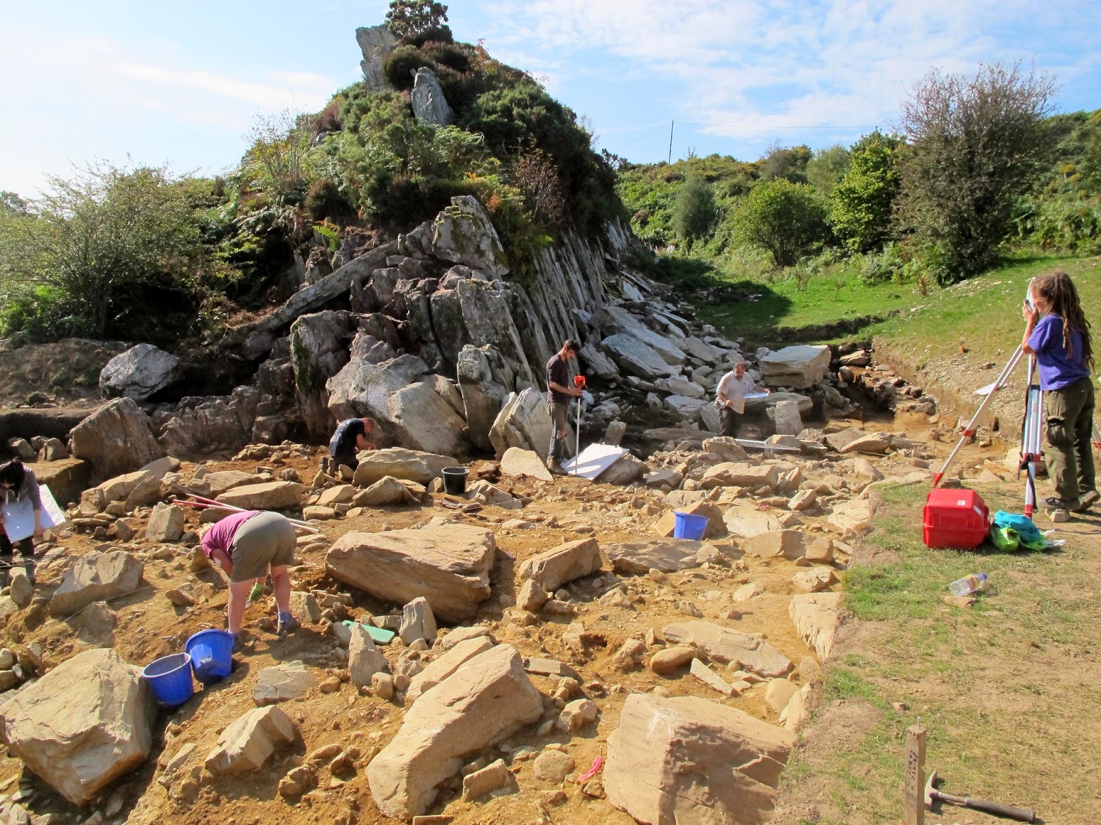
The rock outcrop above is a confirmed Bluestone quarry site. One stone is definitely from here, and it is likely that one or two others are from here too.

Archaeologist Kate giving us a guided tour of the site


Above is an abandoned monolith that was uncovered by the excavations. It is still resting on stone rails that were prepared for the removal of the rock, but at some point during the manoeuvre it cracked and so was left in situ.


In these pictures you can sort of see the stone rails that the monolith is resting on. This was all totally buried beforehand, and was identified by geophysical techniques before being uncovered.


Next to the bluestone quarry and in front of the megalith, these white tags mark the soil layers of the half of a significant find which has been 'left in section'. This means that where the archaeologists have found something significant, they have not dug the whole thing out, but have left a cross section intact so that the structure of the layers can be seen. 

This find was a fire pit, which had been dug and dressed with stones of quartz. This pattern of using it as a fire pit and then dressing it with quartz had been repeated on multiple occasions. Carbon dating of the layers showed that the pit had been used on different occasions over a period of 500 years. The pit itself dated back 10,000 years - so much older than Stonehenge, which is about 4000-5000 years old, and indicates that this site was perhaps significant long before bluestones were quarried from there! I wonder if there was something intrinsic in the area that appealed to those who saw it all those thousands of years ago, or if it was a cultural significance that was passed on down generations - 5000 years of passing-on does seem like a long time though...


Above is a view of the site from the other direction: the rock strewn area contains patches of soil that had been packed down with crushed stone/gravelly bits, possibly as a firm working area for moving the stones. There are also scrape marks on various rocks, showing where the large stones had been shifted over them. 

Towards the far edge (from this angle) of the excavation, this type of ground just drops off and is replaced by fine alluvial silt, indicating that from this point on towards the now-small stream (the other side of the hedge in the background - where the ford was) was all underwater at that time. Beavers would have lived in Britain back then, so their damming activity could well have contributed to flooding localised areas. Fascinating to think of how different everything would have looked back then!


This little part of the quarry area has been positively identified, by chemical fingerprinting, as the exact site from which one of the Stonehenge bluestones was taken. The gap left behind lies behind the first upright finger of rock.


Kate guiding a student - they had found a potential post hole site, so now the student had to begin trowelling instead of brushing the soil away, so as not to blur the demarkation of the find. That area of more browny-orangey soil where they are working did not have the stone/gravel pressed into it, and in this patch they hope to find evidence of living quarters or similar for the stone workers. Back at that time, people put a huge amount of effort into building stone burial chambers for the dead, however they didn't go to the same lengths for their living homes, so evidence of these is relatively scarce.


After this fascinating tour of the dig site we watched a while as archaeologists dug, brushed, measured and recorded, until we decided it was time to head off to Pentre Ifan - a stone burial chamber - which was a short drive away from the dig site. 

We parked up and walked the short path from the road, and once there we had our picnic. My mum was really happy to have been able to go there - as she struggles a bit with mobility she doesn't often get out to places like this, and we were having a lovely and fascinating day out.

Pentre Ifan has been labelled the most impressive megalithic site in Wales, and it dates from a similar time to Stonehenge. You can read more about it here (or of course do an internet search of your choice!) but I'll leave you with the pictures I took yesterday - it may look familiar to you if you have been on my facebook page!


Thank you for joining me for another bit of my local history. I do find it so interesting, and I hope you enjoy it too :)


Tuesday, 16 September 2014

Coast Path Working


Before I get started, I forgot to say that the Caldey Island mail arrived! Doh! Well, it arrived, and I have added in the pictures to my Caldey Island blog post. If you're interested, you can see the pictures here :)

Now then, the other day I promised I would show you what we got up to when I did some voluntary work with the Pembrokeshire Coast National Park Ranger.

It was great fun, and as usual (based on my experience with volunteer work like this) there was a lovely group of lovely and interesting people to meet.

Our work on this occasion was some maintenance on the Coast Path. I have talked before about the Coast Path and how much I love it (here, here,and most recently here), so it felt great to be ‘giving something back’.

The work was required on a small section of path near to the village of St Ishmaels. In the storms experienced by the UK last winter, lots of the coastline around the whole country took quite a battering, and the natural erosion that is constantly occurring was greatly accelerated in some areas. Many sections of the Pembrokeshire Coast Path were affected by soil erosion and cliff falls, with some sections of the Path being left too close to the edge and on unstable land, and other sections even falling away completely!

The National Park Authority has worked hard to fix and renew where possible, and to re-route the Path where this was necessary. We were working at a spot where the path had been re-routed to avoid an area of path that had been lost to cliff falls: the path had been routed through a hedge bank, which had had a gap cut through it for the Path to run. Our job was to restore the cut ends of the hedge bank, using traditional techniques to protect the bank against erosion and to make the work tie in with the original look of the bank.

The new gap in the bank for the re-routed Coast Path


Hedge banks are a pretty old technique for bordering farmland, and also provide an important habitat for lots of wildlife. They are comprised of a bank of soil built up along the boundary, which is then faced with stonework on either side, while the top is left clear for planting. The stonework protect the sides of the bank and maintain its form as a bank, while the roots of the plants grow to bind the whole structure together. It’s clearly a technique that works well, as many hedge banks in the UK are hundreds of years old.

We weren’t building a bank from scratch, so we didn’t have to do much soil work, but we did have to finish off a few courses of stone work in various places (the work had been begun on a previous occasion), then backfill any gaps with soil, before laying turf taken from the sides of the path on any bare areas on top.

First we gathered up some stones, they had been removed from fields by local farmers while ploughing, and the farmers had then offered them to the National Park for the restorations. The Ranger had a nifty little tracked hand-truck for transporting the stones along the path to where they were needed.

Loaded up and ready to go!


We had a wonderful view while we walked along!


When we got to our work spot, you could see the great work that had already been done by the volunteers.

Unloading the stones

The stonework so far


We worked away, trying to find stones that fit in well so that the stone facing would be stable. It was quite time-consuming to get the stones to fit, but very rewarding. We were passed by lots of walkers as we worked, and they were all friendly and said wonderful things about the work done to maintain the Coast Path. Some even asked to take photos of us working! (I must say, I did feel a bit of a fraud, as I had been working there less than an hour when the photos were taken!)

More stone work complete
 
Stonework finished! And back-filled with soil

Once all the stonework was finished, we used mattocks to dig up sections of turf from the sides of the path with which to top off the hedge bank. Once the plants take root, they will bind the new work and keep it strong. Over time, plants will take roots in all of the gaps, and eventually you won’t even see the stones at all.

Finished! With the turf on top - I hope it takes root!


Just a few hours’ work between us, but great results I think :)


Tuesday, 9 September 2014

Island Hopping


Have you heard of Caldey Island? It’s a small island, only about 1 x 1½ miles big. It lies not far off the coast of Pembrokeshire, Wales, near to Tenby. It’s so close you can easily see it from the beach – I have even kayaked out to it many years ago.

But I have never visited it before! And nor had my friend Sarah, who is also from Pembrokeshire and has lived here all her life!


With a good weather forecast last Saturday, we decided to rectify this situation… We headed over to Tenby on Saturday morning, and after a couple of quick errands and a coffee in Sarah’s boyfriend’s favourite coffee shop, Caffe Vista, we wandered down to the harbour to buy our boat tickets to the island. Just £11 each for adults, not too bad for a unique day out.

The boat left from the beach near the harbour, via an ingenious jetty that is moved by tractor to match the tides :)


The weather was glorious, and as we rounded the coast we could see Caldey in full view.


For some reason, I hadn’t expected to see a white sand beach on Caldey, but as we landed the sand and sunshine made it look as though we had travelled to some exotic island, not just somewhere in Wales!


The only thing I had really known about Caldey was that a) they had their own postage stamps, and b) there was a Monastery there. The Monks there are Cistercians, a strict, contemplative offshoot of the Benedictine Order, but none-the-less they are welcoming to their island:


Sarah and I were surprised at quite how many buildings and houses there were! Most were whitewashed, which looked beautiful against the gorgeous blue sky – and really added to the feeling of being abroad! Mediterranean maybe?


But amongst the white, this little cottage caught my eye. I love the colourful fishing buoys and the wiggly driftwood, and the deep veranda is brilliant. Very much like some of the traditional Queenslander-style homes Adam has shown me pictures of over in Australia!


We continued on the path to the small and simple St David’s Church, a Norman construction.


More driftwood in the form of a small cross by the door…


Inside is small and simple, beautiful in its simplicity :)


I love this stained glass – the colours and design are gorgeous, I love how the actual sun is shining through the stained glass sun :)


Back outside… The simple wooden crosses mark the graves of Monks who have passed on from their earthly toil.


We follow the path away from the church and take in the views over the woodland part of the island


Then return to the centre for lunch, which we eat with the Monastery overlooking us. This is certainly not what we expected! We both imagined hewn stone and stark lines, not this magnificent Italianate edifice!


Below the Monastery is the little island post office, where you can buy an envelope with the island stamps – these days they require a normal stamp for postage too, but by posting them on the island they do get marked. I bought a set to send to my mum, and I was hoping to have a photo of it by now to include here, but apparently postage from Caldey is very slow!


Edit to add: The post arrived! Hooray! Here are the Caldey stamps:


We walk towards the western side of the island next, and pass a field of horses. This one catches our eye – his mane makes him look like a New Romantic horse!


Over at the far edge of the island, just a few minutes’ walk from the centre, is the light house. I love the cheery little Lighthouse Keeper at the gateway to the grounds!


Not a great photo, but the land beyond the light house there is the Gower near Swansea, South Wales, and then Devon is visible where it reaches further west past the Welsh bit! Quite amazing, to be as far from the Welsh/English border as you can get in Wales, but just be able to gaze over the sea to England :)


We were too late arriving to have long on the island and the last boat back was at 5pm, so it was time to turn around and head back to the little harbour.

On the boat ride back, I couldn’t resist a photo of the bright red ensign against the blues of the sea and sky :)


On the return, we didn’t land at the beach but instead went further round to land at Tenby Harbour. This meant we passed the Lifeboat Houses: the one to the left is the new one, which is the current Lifeboat House, while the one to the right (the red and white one) is the old Lifeboat House. This one is now privately owned, and has been converted into a home – this transformation was featured on the TV show Grand Designs! 


I had never seen Tenby Harbour’s pastel houses from the sea before…


See this house on the harbourside? See the blue plaque up there? This was something else new to me…


Look closer


In all the time I lived in Pembrokeshire, and in all the time Roald Dahl was such a favourite author of mine, I never knew he used to holiday in Tenby!
 
You learn something new every day :)